

Open User Map
Open User Map transforms any WordPress site into a collaborative, interactive map where visitors contribute locations, routes, and areas without.
About Open User Map
Open User Map is a powerful, user-friendly WordPress plugin that transforms a static map into a dynamic, community-driven tool. Its core purpose is to allow website visitors to contribute directly to a map by adding, editing, and interacting with location markers, all without requiring any coding knowledge. The product is designed for a wide range of users, from small business owners and local community organizers to large-scale tourism boards and real estate developers. The main value proposition is simplicity: it eliminates the need for a Google Maps API key, complex setup procedures, or technical expertise. Instead, it offers a complete, self-contained mapping solution that integrates seamlessly with WordPress. The plugin provides a robust backend with approval workflows, ensuring that all user-generated content is moderated before going live. This balance between open contribution and editorial control makes it a versatile tool for any site that relies on accurate, up-to-date location data. From a strategic perspective, Open User Map shifts the burden of data collection from the site owner to the user base, creating a self-sustaining ecosystem of information. It is not just a map; it is a collaborative platform that empowers communities to build and maintain a shared resource, whether that is a guide to local businesses, a trail map for a national park, or a directory of community events. With over 15,000 active installs and a 100% five-star rating on WordPress.org, it has proven to be a reliable and highly regarded solution in the WordPress ecosystem.
Features of Open User Map
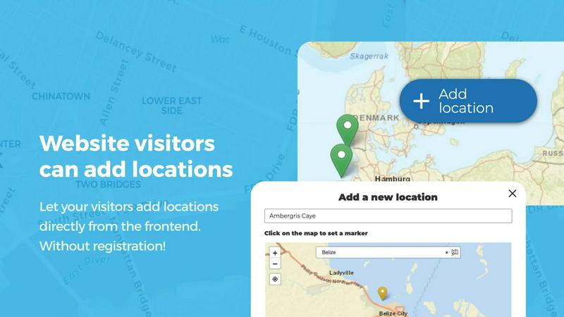
Frontend Location Submissions and Editing
This feature allows any visitor to your website to add a new location to the map by simply clicking an 'Add location' button. They can place a marker, fill in details, and submit the entry for review. The system also supports editing, enabling users to update their own previously submitted locations. This dual functionality ensures that the map remains a living, breathing resource that is constantly refreshed with new data and corrections, all driven by the community. The built-in approval workflow gives site owners full control, as new submissions and edits are held in a pending queue until an administrator reviews and publishes them, preventing spam and ensuring data quality.
Custom Image as Map
This innovative feature breaks the traditional mold of map-based interfaces by allowing you to upload any image and turn it into a fully interactive map. This could be a floor plan for a shopping mall, a seating chart for a stadium, a campus layout for a university, or a diagram of a product. Users can then place markers directly onto this image, and all the standard mapping functionality, such as custom fields, filtering, and location details, works seamlessly. This opens up a world of possibilities for non-geographical mapping applications, making it a versatile tool for event planning, facility management, and educational resources.
Advanced Filter Interface
The Advanced Filter Interface provides a dedicated sidebar that sits next to your map, giving visitors a powerful way to drill down into your location data. This sidebar is not limited to simple category filters; it can be customized to filter by any custom field you have created, such as price range, opening hours, or service type. Additionally, you can add custom HTML content sections within this sidebar for branding, instructions, or supplementary information. This feature transforms the map from a simple visual display into a sophisticated data exploration tool, allowing users to find exactly what they need with precision and speed.
Lines and Areas
This feature extends the capability of Open User Map beyond simple point markers to include the drawing of lines, paths, polygons, and zones directly on the map. This is essential for highlighting trails, service areas, event grounds, neighborhoods, or construction zones. The system automatically calculates distances for lines and area sizes for polygons, providing instant, useful measurements. This functionality is critical for applications like hiking guides, real estate development plans, and event management, where understanding spatial relationships and dimensions is just as important as knowing the location of a specific point.
Use Cases of Open User Map
Community-Driven Local Business Directory
A local Chamber of Commerce or a neighborhood association can use Open User Map to create a comprehensive directory of local businesses. Instead of manually updating a list, they can empower business owners and residents to add new shops, restaurants, and services directly to the map. The approval workflow ensures that all entries are legitimate and accurately categorized. Visitors can then filter by business type, read descriptions, and see user ratings, creating a trusted, community-maintained resource that is always current and far more engaging than a static list.
Interactive Event and Festival Guide
For large events like music festivals, art fairs, or food truck rallies, Open User Map can serve as an interactive guide. Organizers can upload a custom image of the event layout and use the Custom Image as Map feature to place markers for stages, restrooms, food vendors, and first aid stations. Attendees can then use the map to navigate the grounds, filter by vendor type, and even upvote their favorite food stalls. This creates a highly engaging and practical tool that enhances the attendee experience and reduces the burden on event staff for directions.
Tourism and Trail Mapping for Parks
National parks, hiking clubs, and tourism boards can leverage the Lines and Areas feature to map out hiking trails, scenic routes, and camping zones. Visitors can contribute by adding points of interest like viewpoints, water sources, or trail hazards. The automatic distance calculation for trails provides hikers with essential information for trip planning. This creates a dynamic, user-verified map that is far more detailed and useful than a traditional static brochure, encouraging community stewardship and providing real-time updates on trail conditions.
Real Estate and Property Development Showcase
A real estate developer can use Open User Map to showcase a new housing development or commercial project. By using a custom image of the master plan, they can place markers on individual lots or units, each with custom fields for price, square footage, and availability. Potential buyers can filter by these criteria directly on the map, making the property search intuitive and visual. This transforms a standard property listing into an interactive experience that clearly communicates the layout and options of a development, increasing buyer engagement and simplifying the sales process.
Frequently Asked Questions
Do I need a Google Maps API key to use Open User Map?
No, you do not need a Google Maps API key. Open User Map is a self-contained plugin that does not rely on Google Maps. It uses its own mapping engine, which eliminates the need for any external API keys, complex billing setups, or usage limits. This is one of the key features that makes the plugin so easy to set up and use, as you can have a fully functional map running on your site in minutes without any third-party dependencies.
How does the approval workflow for user submissions work?
When a visitor submits a new location or edits an existing one, the submission does not go live immediately. Instead, it is placed in a pending queue within your WordPress admin dashboard. You, as the site administrator, receive a notification and can then review the submission. From the admin panel, you can approve the location to make it visible on the map, or you can reject it and optionally provide a reason to the submitter. This workflow gives you full control over the quality and accuracy of the content on your map.
Can I customize the information collected from users for each location?
Yes, you have extensive control over the data you collect. Open User Map allows you to create and configure custom fields for each location. You can add a variety of field types, including text boxes, links, checkboxes, dropdown menus, and even a star rating system or opening hours. This means you can tailor the submission form to gather exactly the information you need, whether it is a business phone number, a product price, or a review score.
What is the difference between the free version and the PRO version?
The free version of Open User Map, available on WordPress.org, provides a solid set of core features including location submissions, approval workflows, and basic categorization. The PRO version unlocks advanced features such as the Custom Image as Map, Advanced Filter Interface, Lines and Areas, Upvotes & Likes, Star Ratings, and the Opening Hours custom field type. You can try all PRO features for free for 7 days with no credit card required and no automatic conversion to a paid subscription.
Similar to Open User Map

Built2WinWeb AI SEO
AI‑ready websites, WebAgentScan SaaS, and Indexing Pack. MCP, A2A, llms.txt — hand‑coded PHP, complete ownership, flat‑fee, free quote.

Insta Bio
InstaBio is a free Instagram bio generator offering stylish Unicode fonts, attitude lines, and Hindi devotional bios (Radhe Krishna, Mahadev).

Webleadr
Webleadr helps you effortlessly find and contact businesses without websites, turning leads into clients in just a few clicks.

Idearium
Idearium crafts memorable, high-performing websites that drive measurable business growth.

FilexHost
Easily host and share your files in seconds with FilexHost's simple drag-and-drop interface and instant shareable links.

Crawlkit
CrawlKit is the reliable API platform that turns any website into structured data with a single call.

Best Boilerplates
Discover and compare top SaaS boilerplates to accelerate your app launch with ideal features and tech stacks.

Shadcn UI Kit
Accelerate your web development with Shadcn UI Kit's ready-to-use components, templates, and dashboards for React.