

GeoRank
GeoRank turns relocation research into an interactive map where you compare places on sunshine, cost, tax, and visa, then ask AI about your shortlist.
About GeoRank
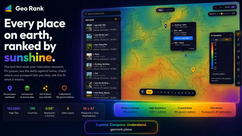
GeoRank is a free, no-signup interactive map tool designed to end the chaotic, multi-tab research process of deciding where to relocate or spend an extended stay abroad. Instead of juggling a weather site, Numbeo, embassy pages, and nomad forums that never communicate with each other, GeoRank layers eight distinct data sets over a global grid with approximately 5 km resolution. This allows users to evaluate potential destinations through a single, unified decision tool. The platform is built for digital nomads, remote workers, expats, and anyone contemplating a significant move. Its core value proposition lies in transforming raw, disparate data into actionable, comparative insights. Users can pin candidate locations, switch to Compare mode to see every metric as a delta against their current home (warmer, cheaper, safer, taxed differently), and leverage an AI assistant that reasons exclusively over their personal shortlist. GeoRank is not just for browsing data; it is engineered for the actual, high-stakes decision of where to live next, providing clarity and confidence in a process often fraught with uncertainty.
Features of GeoRank
Global Interactive Map with 9 Data Layers
GeoRank presents a live, interactive map of the world that users can pan and zoom down to approximately 5 km resolution. The platform features nine distinct, toggleable data layers, each powered by a specific, cited source. These layers include Sunshine (SARAH-3 satellite + ERA5), Temperature, Rainfall, Outdoor Hours, Tax (OECD/PwC/KPMG), Visas & Residency, Cost of Living (from 478 cities), Geopolitical Risk, and Nomad Pulse. Users can toggle any single layer or stack multiple layers to create a custom, multi-dimensional view of any location on earth.
Pin and Compare Mode
GeoRank allows users to pin up to 20 different locations, with these selections saved across sessions for ongoing research. The core analytical feature is Compare mode, where users set their current home as a baseline. Once set, every metric for every pinned location is displayed as a delta against that home base. This transforms abstract numbers into relative, personal insights, instantly showing how many more sunshine hours a place has, how much cheaper it is, or how much safer it is than where the user currently lives.
AI Assistant for Your Shortlist
GeoRank integrates a unique AI chat function that operates exclusively on the user's pinned locations, not a generic knowledge base. The AI is trained to understand the specific data for each pinned place and can reason across all of them in a single response. Users can ask complex, comparative questions like "Which of my 5 places has the best winter?" or "Score my shortlist for sunshine, cost, and low tax combined" and receive cited, grounded answers that are directly relevant to their personal research.
Calibrated Data and Community Sentiment
Unlike raw satellite data, GeoRank's sunshine and temperature layers are calibrated against 182 ground stations (using SARAH-3, ERA5, and CHELSA data) with orographic terrain corrections, ensuring higher accuracy. Complementing this official data is the Nomad Pulse layer, which tracks weekly sentiment from the digital nomad community by processing social posts. This provides a unique, real-time signal of rising, stable, or falling enthusiasm per country and city, offering insights before they become mainstream knowledge.
Use Cases of GeoRank
Comparing Relocation Options for a Remote Worker
A remote worker with a UK passport is considering a move to either Tbilisi or Paphos. They need low taxes, over 2,800 sunshine hours a year, and a low cost of living. Using GeoRank, they pin both cities, set their home as a baseline, and instantly see that Paphos meets the sunshine threshold while Tbilisi does not, but Tbilisi is significantly cheaper. They then ask the AI to compare the two, receiving a cited breakdown of tax regimes, visa durations, and monthly costs, allowing for an informed trade-off analysis.
Planning a Year-Long Extended Stay Abroad
A family is planning a year-long trip and wants to find a winter base with good weather and low geopolitical risk. They use GeoRank to pin several candidate cities across Southeast Asia and Southern Europe. By toggling the Temperature and Geopolitical Risk layers, they can visually identify areas that are both warm and stable. They then use Compare mode to see how the cost of living in each city stacks up against their home, and finally ask the AI, "Which of my pinned places is best for a family with young children for a three-month winter stay?"
Evaluating Tax Implications for a Digital Nomad
A freelancer is trying to decide between several countries with favorable tax regimes for foreign-sourced income. They use GeoRank to pin locations like Dubai, Georgia, and Panama. By activating the Tax layer, they can see the headline tax rates from sources like the OECD, PwC, and KPMG. They then use Compare mode to see the tax delta against their current home country and ask the AI to explain the residency requirements for each destination based on their specific passport, ensuring they understand the full picture before committing.
Assessing a Portfolio of Potential Retirement Destinations
A retiree is researching several countries for a potential move and wants to optimize for sunshine, low cost of living, and safety. They pin a list of 10 cities across Central America, Europe, and Asia. Using GeoRank, they can quickly toggle the Sunshine, Cost of Living, and Geopolitical Risk layers to see a visual overview of how their candidates compare. The AI can then rank their shortlist based on a combined score of their top three criteria, highlighting the trade-offs between a sunnier but more expensive location versus a cheaper, cloudier one.
Frequently Asked Questions
Is GeoRank free to use?
Yes, GeoRank is completely free to use and requires no signup or account creation. All features, including the interactive map, all nine data layers, the pin and compare functionality, and the AI assistant, are accessible without any payment or registration.
What data sources power GeoRank's map layers?
GeoRank uses a combination of high-quality, cited data sources. Sunshine and temperature data comes from SARAH-3 satellite observations and ERA5 reanalysis, calibrated against 182 ground stations. Tax data is sourced from OECD, PwC, and KPMG reports. Cost of living data is drawn from 478 cities. Visa and residency information is compiled for 47 destinations and 10 passports. Geopolitical risk and Nomad Pulse sentiment are sourced from specialized indices and community social posts.
How does the AI assistant work with my pinned locations?
The AI assistant is designed to reason exclusively over the data from your pinned locations. It does not access a generic knowledge base. When you ask a question, it analyzes the specific metrics (sunshine, cost, tax, etc.) for each of your pinned places and provides a comparative, cited answer. This ensures the AI's responses are directly relevant to your personal shortlist and research context.
Can I compare a location against my current home?
Yes, this is a core feature of GeoRank. After pinning your candidate locations, you can switch to Compare mode and set your current home as a baseline. Once set, every metric for every pinned location will be displayed as a delta (difference) against your home. This allows you to instantly see, for example, how much warmer, cheaper, or safer a potential destination is compared to where you live now.
Similar to GeoRank

Orlyn
Privacy-first, cookieless analytics that connects website traffic to real revenue. Sub-1KB script, no cookie banners.

Memorable Contact
Memorable Contact helps you remember people, save conversation details, find contacts using AI-powered search, and share digital business cards easily

GetYouTubeTranscript
Free YouTube transcripts on the web, a Chrome extension, and an API + MCP server so AI assistants can read YouTube.

Sayble
AI copilot that tells you what to say next on live sales calls, then writes the recap and follow-up.


Name Wheel Pro
Can't decide? NameWheelPro spins up random names, numbers, colors, or yes/no answers in seconds. Free, fast, and ad-free.

tally counter
Browser-based gamepad diagnostic tool for testing controller buttons, analog sticks, triggers, D-pad controls, and input detection.
